The Cartographer's Typo That Accidentally Saved America's Wilderness
When Getting Lost Actually Saved the Day
In the world of environmental conservation, victories usually come after decades of lobbying, legal battles, and carefully crafted legislation. But sometimes nature gets its biggest win from the most unlikely source: a tired government cartographer who put a decimal point in the wrong place during the Eisenhower administration.
That tiny mistake on a military survey map inadvertently created one of America's most pristine accidental wilderness preserves, protecting 17,000 acres of ecologically critical land for over four decades before anyone realized what had happened.
The Cold War's Unintended Green Initiative
During the 1950s, the U.S. military was frantically mapping every inch of American territory as part of Cold War defense preparations. Teams of surveyors and cartographers worked around the clock to create detailed topographical maps that could guide everything from missile placement to evacuation routes.
The work was tedious, technical, and absolutely critical to national security. It was also completely dependent on human beings manually transferring coordinates from field surveys to official government maps — a process that, as anyone who's ever used a GPS knows, leaves plenty of room for error.
In this particular case, a cartographer working on surveys of federal land in the Pacific Northwest made what seemed like an insignificant mistake. While transcribing coordinates for a section of mountainous terrain, they misplaced a decimal point in the longitude reading. Instead of marking the land as "available for resource extraction and development," the error caused it to be classified as "under federal review" — a bureaucratic designation that effectively froze all commercial activity.
The Bureaucratic Black Hole
What happened next reveals just how labyrinthine federal land management had become by the mid-20th century. The misclassified land fell into a bureaucratic black hole, bouncing between different agencies and departments without anyone taking definitive action.
The Forest Service thought the Bureau of Land Management was handling it. The BLM assumed it was a military reservation. The Defense Department had no record of claiming it. For decades, the 17,000-acre tract existed in official limbo — too complicated to develop, too confusing to release, and too remote for anyone to notice the error.
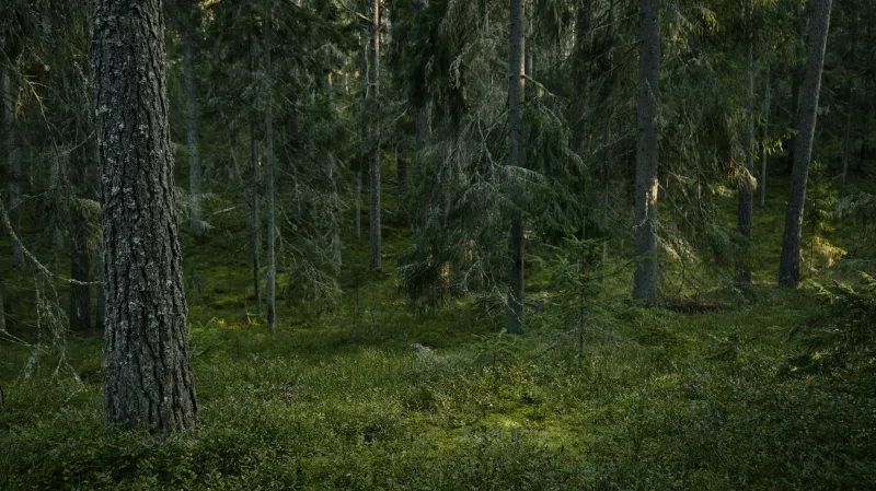
Meanwhile, nature was having a field day. Without human interference, the accidentally protected land became a pristine ecosystem. Old-growth forests that would have been clearcut elsewhere continued growing. Wildlife populations flourished without hunting or habitat disruption. Streams ran clean without mining or industrial runoff.
Discovery: The Mistake That Kept on Giving
The error remained hidden until the 1990s, when new computer mapping systems began cross-referencing decades of paper records. A GIS analyst noticed that a substantial chunk of federal land had coordinates that didn't match any known designation in the database.
Initial investigations suggested the land might be part of a classified military project, but declassified documents revealed no such program. Environmental scientists who hiked into the area found something remarkable: an ecosystem that had been accidentally frozen in time at the exact moment when post-war American development was accelerating everywhere else.
The preserved area contained old-growth forest stands, pristine watersheds, and wildlife populations that had been undisturbed for nearly half a century. Species that had been pushed out of surrounding developed areas had thrived in the accidental sanctuary. It was like finding a biological time capsule.
The Ecological Jackpot
When environmental scientists finally gained access to study the area, they discovered an ecological treasure trove. The accidentally preserved land contained:
- Old-growth forest stands that would have taken centuries to regenerate
- Critical habitat for several endangered species
- Pristine watersheds that served as natural water filtration systems
- Genetic diversity in plant and animal populations that had been lost elsewhere
The economic value of the ecosystem services provided by this "mistake" — water purification, carbon sequestration, biodiversity preservation — was estimated in the millions of dollars annually. The accidental preserve had been providing environmental benefits for decades without costing taxpayers a penny in management fees.
The Irony of Incompetence
The discovery sparked heated debates about American conservation policy. Environmental groups pointed out that a simple clerical error had accomplished more for wilderness preservation than decades of legislative efforts. The accidentally protected land was in better ecological condition than many areas that had been deliberately designated as nature preserves but lacked adequate funding or management.
Conservation scientists began referring to it as "the mistake that worked," highlighting the paradox that human negligence had sometimes proven more effective at protecting nature than human intention. The case became a talking point for advocates of "passive conservation" — the idea that sometimes the best thing humans can do for the environment is simply leave it alone.
Making It Official
Once the error was discovered, federal agencies faced a choice: correct the mistake and open the land to development, or acknowledge that the accident had created something valuable and make the protection official.
After extensive environmental impact studies and public comment periods, the land was formally designated as a protected wilderness area. The cartographer's decimal point error became the foundation for legitimate conservation legislation, proving that sometimes the best environmental policy comes from admitting when a mistake actually worked out better than the original plan.
The Lesson of Accidental Conservation
The story of America's most successful mapping error raises uncomfortable questions about how we approach environmental protection. If a simple bureaucratic mistake could preserve 17,000 acres of pristine wilderness more effectively than decades of intentional conservation efforts, what does that say about our systematic approach to environmental policy?
Today, the former "mapping error" is officially protected wilderness, complete with hiking trails and educational programs about both its ecological significance and its hilariously accidental origins. Park rangers love telling visitors that they're standing in a nature preserve that exists because someone put a decimal point in the wrong place during the Eisenhower administration.
Sometimes the best environmental policy is no policy at all — just a tired government employee making a tiny mistake that turns out to be exactly what nature needed.